
Page 26 - Demo
P. 26
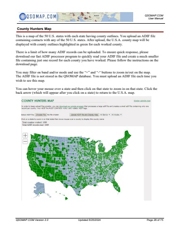
QSOMAP.COM User ManualQSOMAP.COM Version 2.0 Updated 6/25/2024 Page 26 of 75County Hunters MapThis is a map of the 50 U.S. states with each state having county outlines. You upload an ADIF file containing contacts with any of the 50 U.S. states. After upload, the U.S.A. county map will be displayed with county outlines highlighted in green for each worked county.There is a limit of how many ADIF records can be uploaded. To ensure quick response, please download our fast ADIF processor program to quickly read your ADIF file and create a much smaller file containing just one record for each county you have worked. Please follow the instructions on the download page.You may filter on band and/or mode and use the %u201c+%u201d and %u201c-%u201c buttons to zoom in/out on the map.The ADIF file is not stored in the QSOMAP database. You must upload an ADIF file each time you wish to see this map.You can hover your mouse over a state and then click on that state to zoom in on that state. Click the back arrow (which will appear after you click on a state) to return to the U.S.A. map.
