
Page 1 - Demo
P. 1
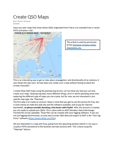
Create QSO MapsKarl Heinz KremerK5KHKHave you seen maps that show where QSOs originated from? Here is an example from a recent POTA activation I did:This is an interesting way to get an idea about propagation, and directionality of an antenna. It also shows the skip zone. So how does one create such a map without having to place the arrows manually? I create these QSO maps using the qsomap.org service. Let me show you how you can also create such maps. Qsomap.org does many different things, and it%u2019s worth spending some time exploring the different type of maps you can create, but for now, we are interested in one specific map type, the %u201cPolymap%u201d. The first step is to create an account. Keep in mind that you get to use this service for free, but it costs money to make the web site and the software available, and to pay for internet bandwidth, so please consider donating a few bucks with PayPal. After the account is created, you are ready to upload your QSOs. This is done with an ADIF (Amateur Data Interchange Format) file can be uploaded. These files can be created with your logging software. If you are not yet logging electronically, an easy way to enter QSO data and export to ADIF is the %u201cFast Log Entry%u201d software (https://www.df3cb.com/fle/). We are interested in a map with lines, going from the operating location (which in my case is usually a POTA activation) to the locations we had contacts with. This is done using the %u201cPolymap%u201d feature.This article is used by permissionof the Rochester Amateur Radio Association, Inc.
