
Page 3 - Demo
P. 3
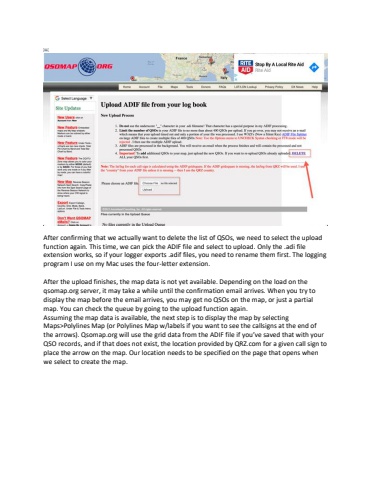
%ufffcAfter confirming that we actually want to delete the list of QSOs, we need to select the upload function again. This time, we can pick the ADIF file and select to upload. Only the .adi file extension works, so if your logger exports .adif files, you need to rename them first. The logging program I use on my Mac uses the four-letter extension. After the upload finishes, the map data is not yet available. Depending on the load on the qsomap.org server, it may take a while until the confirmation email arrives. When you try to display the map before the email arrives, you may get no QSOs on the map, or just a partial map. You can check the queue by going to the upload function again.Assuming the map data is available, the next step is to display the map by selecting Maps>Polylines Map (or Polylines Map w/labels if you want to see the callsigns at the end of the arrows). Qsomap.org will use the grid data from the ADIF file if you%u2019ve saved that with your QSO records, and if that does not exist, the location provided by QRZ.com for a given call sign to place the arrow on the map. Our location needs to be specified on the page that opens when we select to create the map.
